GeoNotes
Cypress
Hills and area
Frenchman River Valley and the distinct Whitemud Formation. Photo: Charles Kuss
THE
CYPRESS HILLS STRATIGRAPHIC SEQUENCE
the
significance of the K-T boundary (65 Ma) and a major extinction event
The
generalized stratigraphic sequence of the Cypress Hills (Fig. 1)
consists of six formations beginning with the oldest: Eastend,
Whitemud, Battle, Frenchman, Ravenscrag, and Cypress Hills resting on
the marine Bearpaw shales that dominate the southern prairie region
around the Cypress Hills. The shales were named after where they
were first discovered near the Bearpaw Mountains in Montana.
 The towns of Eastend, Maple Creek, and Piapot, and the once hamlet of Ravenscrag and South Fork are built on the Bearpaw Formation. Dollard is situated on the Eastend Formation, and Shaunavon is built on the Eastend/Whitemud/Battle Formation.
The
warm shallow Bearpaw Sea (77-68 Ma) extended down the entire length
of western North America from the Arctic Ocean to the Gulf of Mexico.
This resulted in the deposition of the Bearpaw Formation. The
formation is 250 m thick and was deposited during a relatively quiet
geological time when mechanical erosion was low and rivers were
carrying mainly finer suspended silts and clay minerals into the sea.
There are also layers of volcanic ash deposits from the western
Cordilleran orogeny that have been altered to the clay mineral
bentonite. The shale and clay of the upper Bearpaw Formation in this
area of the Cypress Hills contains more sand, indicating an increase
in mechanical weathering from geological activity in the west and
southwest. The upper Bearpaw Formation also contains abundant gypsum
(selenite) and clay iron concretions. Selenite, an evaporative
mineral, can form crystals after a rain as the muddy clay dries.
Overall,
the shallow sea life of the Bearpaw Formation consists of a variety
of reptiles, vertebrates, and invertebrate marine fossils, including gem-quality ammonites found in some areas, and a diversity of marine
mollusks.
With
the Bearpaw Sea starting to disappear after 69
Ma, and with
continued
periodic
orogenic
activity in the southwest,
coarser material was being intermittently
deposited
as
sandstone. The Eastend Formation overlies the Bearpaw Formation
and
consists mainly of 125
m of
sandstone,
green-gray
shale,
and lignite
coal
seams.
The lower portion of the Eastend
Formation
is
made up of
marine deposits containing
marine mollusks, while
the upper part of the formation consists
of
non-marine
sand,
silts, and clays.
The
formation also has round
and ovoid
concretionary
layers.
The
non-marine
deposits are
an indication that
the Bearpaw Sea has
more or less
disappeared
from
the area,
and the low
gradient rivers
and
streams are
now
depositing
their load into
a low-lying coastal
plain
containing
swamps and
marshes
that
are
today
thin
lignite
coal
seams, and
the
silts are
the
shale
beds. Shallow
lakes and ponds are also characteristic of a
low-lying coastal plain geomorphology.
Lithic
grain
analysis
of the non-marine Upper Eastend Formation revealed rapid mechanical
weathering of newly extruded volcanic rocks. In
contrast,
the
lithology of the overlying
Whitemud
Formation reveals
a very quiet
orogenic period resembling old worn down mountain ranges predominated
by chemical weathering that altered the feldspar-rich volcanic
tuffs, flows, and
intrusive materials, and the feldspar-rich metamorphic rocks and
clasts into
kaolinitic clays at the source, and
during and after the
deposition
of
source materials.
The
lithic
analysis also
suggests that the
source material for both the Upper Eastend and Whitemud Formations
came from Upper Cretaceous volcanic rocks, Precambrian rocks,
Paleozoic metamorphic and carbonate rocks, all
situated in Montana. These
rocks are
thought to come
from
the Late Cretaceous (81-74 Ma)
igneous
uplifts of the Elkhorn
Mountains, 35 km SSE of Helena, MT, predating
the Eocene
(55-50
Ma) Bearpaw
Mountains and Sweetgrass Hills igneous
intrusive
uplifts.
The
Whitemud Formation is 8 m thick and is
characterized by white kaolinitic refractory clay that was
commercially mined
around
Eastend and Ravenscrag in open pits during
the
early
to late 20th century and
is still mined today (quarry seen along Bench Road) by
Plainsman Clays Ltd of Medicine Hat, AB.
The
clay is used in the manufacture of a wide range of products, from pottery to
sewer pipes. Refractory
clay
materials have the commercial
advantage
of being resistant to decomposition by heat, pressure, or chemical
attack, and they
retain
their
strength
and form at high temperatures. The
Whitemud
Formation
also contains brown fissile carbonaceous shales, siltstones, and thin
beds of lignite coal. Plant fossils in the carbonaceous shales
consist
of
aquatic
plants such as water lilies, and
trees and shrubs related to figs, hickories, and redwoods.
Microfossils
of spores and seed cuticles are also found.
Indirect
evidence of vertebrate fossils is scattered coprolites (fossilized
feces) ranging
in size from 2-23 cm, representing
fish feces, terrestrial
reptiles,
and fossilized unexpelled intestinal remains. The
coprolites are well preserved as siderite (iron carbonate mineral)
and iron
hydroxides.
The
Whitemud sediments are non-marine deposits on a floodplain overlain
by the marine Battle Formation. It appears the Bearpaw Sea hadn’t
completely left the area and periodically transgressed onto the low-lying marshlands, depositing the 10 m thick distinctive mauve grey to
purplish-brown mudstone or shale of the Battle Formation. The shale
contains volcanic ash that has been altered to bentonite and
montmorillonitic clay that forms a popcorn-like crust upon
weathering.
The
Battle Formation is thought to be marine because it contains
foraminifera, single-cell shelled marine organisms. The formation is
poorly fossilized, containing spores, bone fragments, algal remains,
and carbonized wood. After the regression of the Bearpaw Sea, there
was a period of erosion, and the missing stratigraphy of the Battle
Formation created an unconformity. The erosion ended with the
deposition of the Frenchman Formation.
The
Frenchman Formation is an olive green to brown 75 m thick alluvial floodplain deposit (Fig. 2) consisting of two non-marine facies of sand
and clay that look similar to the Eastend Formation, suggesting a
return to an alluvial floodplain environment. The source rocks for
the Frenchman Formation are thought to have come from fast mechanical
weathering of Late Cretaceous volcanic rocks in SW Montana that were
extruded before or during the deposition of the Frenchman Formation.
These same rocks are also thought to be the source of the overlying
Ravenscrag Formation. The boundary between the two formations
created the well-known, and somewhat mysterious, Cretaceous-Tertiary
(K-T), known today as the Cretaceous-Paleogene (K-Pg), a boundary which
in this area has preserved a continuous sequence of time before,
during, and after the controversial mass extinction event.
 Figure 2: Example of an alluvial floodplain deposit with braided stream channels 66 Ma. The mountainous area represents the north-central Montana uplifts. Image: University of Notre Dame.
Fossilized
plant remains are common in the Frenchman Formation, but remain
mostly unidentified. Fauna of the Frenchman are crocodiles, lizards,
snakes, turtles, champsosaurs, a few birds, and 14 dinosaur species.
Champsosaurs fossil discoveries continue with the newest find made in
August of 2020 near Climax, SK, just above the K-T boundary. The
Triceratops (65 Ma) account for 70% of the dinosaur fossil material
in the formation. In recent years, the Frenchman Formation has become
world-famous with the 1991 discovery of a significant 65.5-65 Ma
megafauna, Tyrannosaurus rex, or T. rex (Scotty) at Chambery Coulee,
27 km SE of Eastend, SK, along the Frenchman River valley near Hwy 37.
Scotty,
possibly
the largest T.rex uncovered so far,
was found 28.3 m below the iridium-enriched
K-T
boundary buried in
the
sand
of
a
once
gently meandering river channel
point
sand
bar.
The
disarticulated
skeleton
is
75%
complete, a rarity for
T. rex skeletons. The
exact
cause
of death is unknown, and the
reptile died
at or near the burial site. There is bone degradation indicating extensive
aerial
exposure before the
gradual
final
burial.
Scotty’s
pathology is interesting, according to Wikipedia: “Like
other T.
rex fossils,
Scotty shows signs of trichomonas,
a parasitic infection in the jaw that left visible holes in the bone
and was unique to this specific species of dinosaur. Additionally,
a broken and healed rib on its right side, broken tail vertebra, as
well as a hole near the eye socket are possibly the result of
another T.
rex attack. Other
abnormalities, such as impacted teeth, suggest that Scotty was not
only bitten, but also bit other animals.
Vessel-like
structures found in a rib that show partial Fe-mineralisation
indicate that Scotty died within months of suffering the bone
fracture.”
Scotty’s
skeletal discovery was associated with other bones and plants,
another rarity, revealing the paleoenvironment at the time of burial.
Embedded with the skeleton are a few fossils of ferns, gymnosperms,
and angiosperms, along with fish scales, and shells of gastropods and
clams.
The
T. rexes roamed in a broad valley with abundant deciduous flora.
Since Saskatchewan was farther north 65 Ma ago than today, with
reduced daylight, the vegetation entered into seasonal dormancy, dropping its leaves in fall colour style. This left the herbivorous
with a shortage of food, and in turn, left the T. rexes also
without food. There is some speculation that the T. rexes followed the
migrating herbivores to new food sources. The regional climate was
subtropical-warm temperate without winter or frost, but had a seasonal
drought. A regional study showed that the stratigraphy and
biodiversity were maintained by local environmental conditions of
less than 200 km. The annual mean temperature was 12°C with annual
precipitation of 1120 mm. Compared with today’s annual mean
temperature of 2°C and 380 mm of average annual precipitation.
The
Frenchman Formation underlies the Ravenscrag Formation, which is a 70
m thick non-marine alluvial floodplain deposit interbedded with
sands, silts, and clays with an eastward thickening of sediment.
Found throughout the Ravenscrag Formation are abundant, well-preserved
plant remains, coal seams, and scattered carbonaceous material.
Megaflora fossils indicate marked seasonality in a subtropical-warm
temperate environment. Channelling, scouring, and filling are present.
Also within the formation are several cycles similar to the Whitemud
Formation, indicating a quieter geological time where chemical
weathering predominated over mechanical weathering at the source.
Within the Ravenscrag Formation is the Willowbunch Member, which is
also similar to the Whitemud Formation, consisting of fine-grained
sand, silt, and clay.
An
interesting feature of
the Ravenscrag Formation and
other exposed coal-bearing formations is
the rusty orange colour in the baked
clay
near coal seams that have caught fire during
lightning
strikes. On
rare occasions, coal seams were intentionally set on fire by individuals.
The
Ravenscrag Formation has economically
low sulfur coal used
to fuel Saskatchewan’s electric power stations, and the clays are
used to make a variety of brick products. Coal
mining
is done in eastern Saskatchewan near
Estevan, close
to
the
electric
power
plants. According
to local accounts,
small-scale limited lignite coal mining has
occurred along the Frenchman River valley and South Fork, SK, for personal use; however,
there
were
and
are no major commercial
coal
mining operations in the area. The
first commercial coal mining operation began in SE SK near Roche
Percée in 1880.
The
Ravenscrag Formation was exposed to erosion, creating an unconformity
for some time before the Eocene orogenic phase in north-central
Montana produced the igneous intrusive uplift complex, which resulted
in the emergence of the Bearpaw Mountains and the Sweetgrass Hills.
Rivers carrying the mechanically weathered rock from this intrusive
complex ended the erosion of the Ravenscrag Formation with the
fluvial deposition of coarse gravel and sand, creating the youngest
formation in the stratigraphic sequence of the Cypress Hills, the
Cypress Hills Formation.
The
Frenchman-Ravenscrag (K-T) boundary is at the base or within the
basal Ravenscrag lignite/anthracite coal seam and represents a
regional and global paleoclimate change along with what is perceived
as a major extinction event. The local site “Hwy 37”, south of
Shaunavon, SK, below the 1.5 m Ferris No.1 coal seam, offers one of the
best exposures of the K-T boundary in North America.
The
1-2 cm wide K-T boundary clay deposits first came to light in 1980
when a team of researchers, led by Luis Alvarez, travelled the world
investigating this unusual boundary. The shocked quartz and high
amounts of iridium in the boundary clay suggested the anomaly is
associated with an impactor. Iridium is rare in the Earth’s crust
and is found with heavier elements along with iron near the Earth’s
core. Asteroids and comets have a higher abundance of iridium that
can be used as an indicator element to determine whether the source
of an event is terrestrial or extraterrestrial.
 Sample of the 1 cm K-T boundary clay line at the T.rex Discovery Centre, Eastend, SK. Photo: Charles Kuss
A
large
impact
crater
from
an extraterrestrial source was
discovered in
the Gulf of Mexico during
the late 1970s by geophysicists looking for oil. It
wasn’t until 1991 when the impactor site
was confirmed
using
commercial
offshore
oil drilling data and
drill core analysis that
this may be the possible
cause of the K-T boundary
anomaly, and
that the impactor may
have had
a
global
paleoenvironmental significance.
The large buried crater
is
located on
the
northern
tip of the
Yucatan
Peninsula
in the Gulf of Mexico near
the town of Chicxulub, Mexico.
At
the time of the
impact
(65
Ma),
the northern tip was underwater, creating
a massive
tsunami with
tsunami deposits discovered
all
around the gulf. Since
then, ejecta
deposits have
been
found at multiple land-based sites in
North and Central America (Fig.
3).
 Figure 3: The Chicxulub impact site 65 million years ago. The white area is submerged land, from Kring (2019), Lunar and Planetary Institute.
The
impactor is
believed
to have been 10 km
in diameter, coming
in at an angle
of 45-60
degrees
from the NE, travelling
20+ km/sec, creating
a 240
km
wide
crater
that’s
25-30 km
deep. It’s
believed the impact created a superheated plasma pulse of 10,000 C
lasting a few minutes that
created
a shock wave and airburst, sending material and
steam high
up
into
the atmosphere
and around the globe.
This material eventually settled down
on
the surface,
creating
the
K-T boundary clay deposit. Soot
in
the form of a black carbon layer is
also common near
and at
the boundary, suggesting massive global grass, brush, and forest
fires.
The
Chicxulub impact theory is the
one most
often cited as a
possible
cause of the massive K-T extinction, where 75% of species
disappeared because
of
severe
environmental
degradation.
The
Earth has
experienced
a total of five mass extinction events with
similar consequences, and
now
possibly
a sixth (Fig. 4)
may
be
underway in
the last 100,000 years.
The
sixth event has an additional threat to life,
past
and current
anthropogenic activities,
including
overhunting, pollution, and
deforestation that
have
and are
attributing
to
species
habitat
destruction, leading
to
many
species
disappearing
permanently.
 Figure 4: A generalized geologic time scale. ‘Ma’ is an abbreviation for millions of years. The asterisks indicate major extinction events, and the question mark asterisk is a possible major extinction event currently underway. Image modified after USGS.
The
impact
theory, which
usually
mentions
an asteroid,
is popular but controversial. It’s
not known whether the impactor was a comet or an asteroid.
The
timing of the impact and the mass extinctions
are
also
in
question, with
evidence
supporting
possibly
two
impacts,
one
predating
the K-T boundary by 400,000
years, and
the
other
100,000
years after the K-T boundary.
Detailed
stratigraphy and biotic analysis also seem to indicate that the impactors
themselves
were
not the cause of the mass extinctions.
There
is evidence of large
amounts of soot worldwide
before
the K-T boundary
that
shows signs
of renewed
vegetation growth.
There
is also
the
question of whether the dinosaurs died out suddenly
at
the K-T boundary or
were already
reduced in numbers and had
died out long before the K-T boundary event.
Large
cosmic impactors have
upset the Earth’s geological stability, disrupted
numerous
sensitive
environments and
ecosystems, and destroyed
the
food
chain, making
it difficult for some species to survive.
Species
with a
low
tolerance to environmental change and
a very narrow geographical distribution
are
the first to disappear. Those
with higher tolerance and
broader geographical range will
survive until their tolerance threshold is reached, and they
too
will
disappear. Some
species may become locally extinct, but survive elsewhere.
There
are
hints
of
another
cosmic disruptor
in
addition to comets and asteroids, and
for
this, we need to look at a more
recent
event, the Younger Dryas event of
13,000
years ago.
To
clarify
a
previous statement,
there
is no
difference between the
K-T and K-Pg boundaries. In
2008, the Tertiary Period
was
replaced with
the
Paleogene
and Neogene
periods
(Fig.
4).
Any
articles written before 2008 use K-T, and articles written after 2008
use K-Pg. Since most of the articles in the sources
are
older
than
2008,
K-T
is
used and, when
needed,
can be substituted for K-Pg.
Sources:
Adatte,
Thierry; Kramar, Utz; et al;
https://www.academia.edu/8937549/More_evidence_that_the_Chicxulub_impact_predates_the_K_T_mass_extinction?auto=download&email_work_card=download-paper;
Meteoritics & Planetary Science;Vol 39, No. 7; Pgs 1127-1144;
2004
Bamforth,
Emily L.; (PDF)
Log Jams and Juveniles: Unusual deposits at the K-Pg Boundary in the
Frenchman Formation (66 Ma) of Saskatchewan, Canada
(researchgate.net); Royal
Saskatchewan Museum, T.rex Discovery Centre; Eastend, SK; September
2019
Bamforth,
Emily L.;
(PDF)
The Triceratops 'Baby Book': An Update on Juvenile Ceratopsians from
the Frenchman Formation (66 Ma) of Saskatchewan, Canada.
(researchgate.net);
Canadian Palaeontology Conference, Preceedings
Vol No 15; Saskatoon, SK; September 2018
Bamforth,
Emily L; Local
environmental conditions drove vertebrate biodiversity immediately
prior to the K/Pg Extinction: Evidence from Central Canada. |
Request PDF (researchgate.net);
Journal
of Vertebrate Paleontology 72nd
Annual Meeting, Programs and Abstracts: 59;
October
2012
Binda,
Pier L., et al; AAPG
Datapages/Archives: STRATIGRAPHY, PALEONTOLOGY, AND ASPECTS OF
DIAGENESIS OF THE WHITEMUD FORMATION (MAASTRICHTIAN) OF ALBERTA AND
SASKATCHEWAN (Abstract); Sixth International Williston Basin
Symposium, SP11; Pgs 179-192; October 7, 1991
Byers,
P. N.; Mineralogy
and origin of the upper Eastend and Whitemud Formations of
south-central and southwestern Saskatchewan and southeastern Alberta
(cdnsciencepub.com); Canadian Journal of Earth Sciences; Vol 6,
No 2; Pgs 317-334; 1969
Corliss,
William, R.; Anomalies
in Geology. Physical, Chemical, Biological : A Catalog of Geological
Anomalies (archive.org); The Sourcebook Project; Glen Arms, MD;
1989
Firestone,
Richard; West, Allen; et al; The Cycle of Cosmic Catastrophes; Bear
& Company; Rochester, VT; 2006
Furnival,
G.M; Cypress Lake Map Area, Saskatchewan; GEOSCAN
Search Results: Fastlink (nrcan.gc.ca); Geological
Survey of Canada; Memoir 242; 1946
Geology
- Cypress Hills Provincial Park | Alberta Parks; Government
of Alberta; Edmonton, AB; June 28, 2017
Keller,
Gerta, et al; Chicxulub
impact predates the K-T boundary mass extinction | PNAS; The
National Academy of Science; Vol 101, No 11; Pgs 3753-3758; March
16, 2004
Keller,
G,; et al; Multiple Impacts Across the Cretaceous-Tertiary Boundary;
doi:10.1016/S0012-8252(02)00162-9
(redciencia.cu); Earth-Science
Reviews; Vol 62, Issues 3-4; Pgs. 327-363; Sept 2003
Kring,
David A.; Chicxulub Impact Event; Chicxulub
Impact Event (usra.edu); Lunar
and Planetary Institute; Houston, TX; 2019
Kolaceke,
Anezka; Velez, Maria I.; et al; (PDF) Lithostratigraphy of Sections in the Vicinity of the Excavation Site of a Nearly Complete Tyrannosaurus rex Skeleton (Scotty) in Southwestern Saskatchewan, Canada (researchgate.net);
Saskatchewan Geological Survey; Summary of Investigations; Vol 1;
Miscellaneous
Report 2018-4.1, Paper A-6;
2018
Kupsch,
W. O.; Geology of Eastern Cypress Hills (Knollys and Dollard
Quadrangles); Publications
Saskatchewan;
Saskatchewan
Geological
Survey;
Report 20; Regina, SK; 1956
Marsh,
Arden; Berenyi, Jason; An Overview of Coals in Saskatchewan;
Saskatchewan Ministry of Energy and Resources; Government of
Saskatchewan; Regina, SK;
https://www.bing.com/ck/a?!&&p=7741299d73ec00b5JmltdHM9MTY3MzY1NDQwMCZpZ3VpZD0yYTNiMmNmNC02YWUzLTYwNjUtMmJkMS0zZTljNmI0YjYxYzMmaW5zaWQ9NTE2OQ&ptn=3&hsh=3&fclid=2a3b2cf4-6ae3-6065-2bd1-3e9c6b4b61c3&psq=95116-OH2008_TS4_Marsh%2520%2520coal%2520reserves%2c%2520mines%2520sk.pdf&u=a1aHR0cHM6Ly9wdWJzYXNrZGV2LmJsb2IuY29yZS53aW5kb3dzLm5ldC9wdWJzYXNrLXByb2QvOTUxMTYvOTUxMTYtT0gyMDA4X1RTNF9NYXJzaC5wZGY&ntb=1
(downloads PDF); Site accessed 1-14-2023
McIver,
Elisabeth E.; The paleoenvironment of Tyrannosaurus rex from
southwestern Saskatcheewan, Canada;
https://cdnsciencepub.com/doi/10.1139/e01-073;
Canadian
Journal of Earth Sciences;
Vol 39, No
2;
Pgs 207-221; 2002
O’Dale,
Charles; CHICXULUB
IMPACT STRUCTURE – Crater Explorer; Ottawa,
ON
Plainsman
Clays Ltd; Medicine Hat, AB; Plainsman
Clays; Site
accessed 1-12-2023
USGS;
File:
Geologic time scale;
https://commons.wikimedia.org/wiki/File:Geologic_time_scale.jpg;
Washington,
DC; July 2010
Robin,
C.M.I.; et al; NAD83v70VG: A New National Crustal Velocity Model of
Canada; GEOSCAN:
More Report (nrcan.gc.ca); National
Resources Canada; Geometrics Canada Open File 0062; Ottawa, ON; 2020
Water
Deposits;
www.3.nd.edu/~cneal/PlanetEarth/Lab-Deserts/Depositional.html;
University of Notre Dame; Notre
Dame, IN, USA
Wikipedia,
Scotty (dinosaur); June 19, 2026; Scotty
(dinosaur) – Wikipedia; Site accessed 6-21-2026.
Wikipedia,
The
Free Encyclopedia;
Washington, DC; 2020
 The
perpendicular joints of the Ravenscrag Formation 4 km SSW of Fort
Walsh, also known as the “Mystery Rocks”. The main structural
features in the Cypress Hills are joints. What causes joints to form
in rock is somewhat debatable, but in the Cypress Hills they may have
been created by the isostatic rebound related to erosional unloading
of the Cypress Hills Formation and/or the isostatic adjustments from
the many glaciations during the past 2.6 Ma. Today, northern Canada
that is still rebounding 5-8+ mm/year from the Wisconsin deglaciation
and the Cypress Hills and area is subsiding 2-3 mm/year. Photo:
Charles Kuss
The
perpendicular joints of the Ravenscrag Formation 4 km SSW of Fort
Walsh, also known as the “Mystery Rocks”. The main structural
features in the Cypress Hills are joints. What causes joints to form
in rock is somewhat debatable, but in the Cypress Hills they may have
been created by the isostatic rebound related to erosional unloading
of the Cypress Hills Formation and/or the isostatic adjustments from
the many glaciations during the past 2.6 Ma. Today, northern Canada
that is still rebounding 5-8+ mm/year from the Wisconsin deglaciation
and the Cypress Hills and area is subsiding 2-3 mm/year. Photo:
Charles Kuss
 Display of T. rex (Scotty) at the T.rex Discovery Centre. Photo: Charles Kuss
 Triceratops display at the T.rex Discovery Centre. Discovered in the Frenchman Formation near Hwy 37. Photo: Charles Kuss
 Large
well well-cemented concretionary “log” structures in the Frenchman
Formation along the Frenchman River valley. Photo: Charles Kuss
Large
well well-cemented concretionary “log” structures in the Frenchman
Formation along the Frenchman River valley. Photo: Charles Kuss
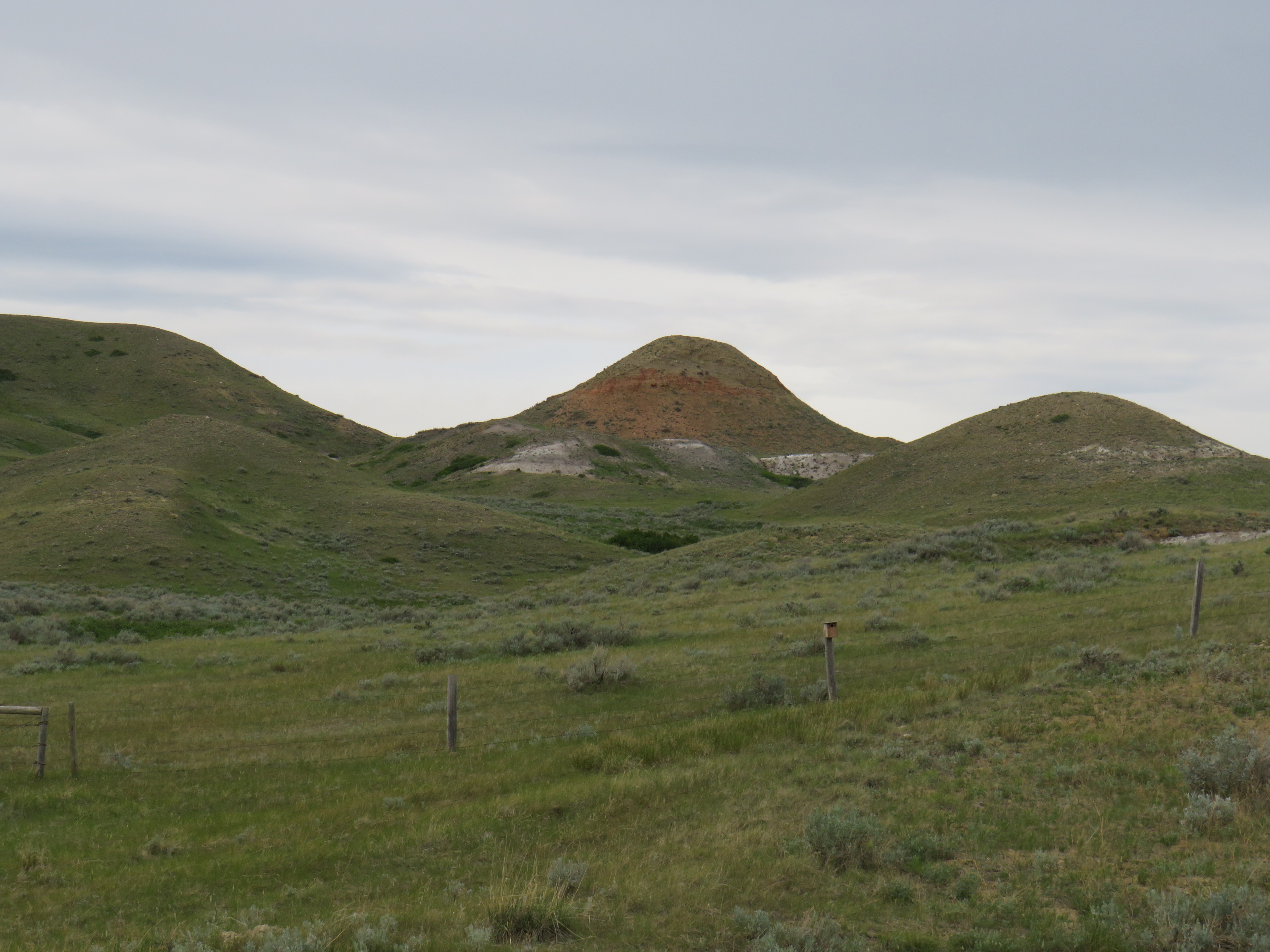
Chocolate
Peak, approximately 2 km NW of Eastend, SK, on grid road 614.
According
to local accounts, the
red baked clay visible
on the hillside is from
a coal seam fire set by a Whitemud clay miner in the 1930s to get
access to the clay. Apparently, the seam burned for many months
before extinguishing itself. Image:
Charles Kuss
Charles Kuss 2021 Updated: 06/22/2026
 Figure 1: A generalized geologic time scale. ‘Ma’ is an abbreviation for millions of years of age. Image from USGS
 Figure 2: Example of a braided alluvial plain. The Eocene (45 Ma) geography before the emergence of the Cypress Hills Plateau. From Leckie and Cheel (1989).
  Figure 3: The source rock for the Cypress Hills Formation (CHF). Abbreviations: Adel Mountains (AM), Pioneer Batholith (P), Aksaroka region (A), and Elkhorn Mountains (E). The general river and stream flow direction is indicated by the NE arrow above the Rose diagram. From Leckie and Cheel (1989).
  Outcrop of the Cypress Hills Formation at the Conglomerate Cliffs. The Conglomerate Cliffs are located at the end of Conglomerate Cliff Rd 4.4 km NNE from Range Stn Rd and, the Conglomerate Cliff Rd turn off is located 3.2 km NW along Range Stn Rd from the end of HWY 271 at the turn off to Fort Walsh. Photo: Charles Kuss
 Close-up of the Cypress Hills Formation outcrop at the Conglomerate Cliffs, 8.6 km NNE of Fort Walsh, SK. Photo: Charles Kuss
  Contact
between the loosely and poorly consolidated conglomerate of the
Cypress Hills Formation and the underlying fine grained sandstone of
the Ravenscrag Formation at Jones’ Peak north of the Frenchman
River Valley on the Middle Bench Road. Jones’ Peak overlooks the
beautiful Frenchman River Valley and is 12 km NE and east off grid
road 614 or 5.50 km west off grid road 614. Both directions take you
on to the Middle Bench Road. At the Jones’ Peak sign post it’s
another 3 km south to the peak. Photo: Charles Kuss
Contact
between the loosely and poorly consolidated conglomerate of the
Cypress Hills Formation and the underlying fine grained sandstone of
the Ravenscrag Formation at Jones’ Peak north of the Frenchman
River Valley on the Middle Bench Road. Jones’ Peak overlooks the
beautiful Frenchman River Valley and is 12 km NE and east off grid
road 614 or 5.50 km west off grid road 614. Both directions take you
on to the Middle Bench Road. At the Jones’ Peak sign post it’s
another 3 km south to the peak. Photo: Charles Kuss An example of imbricated clasts piggy backing each other. Image: Wikipedia.org
 The brontothere of Eocene age at the T-Rex Discovery Centre, Eastend, SK. Photo: Charles Kuss
 Example of a Cypress Hills Formation cobble displaying arcuate percussion marks indicating strong current flow as cobbles slammed into each other. Photo: Charles Kuss